Johannesburg Maps and Orientation
(Johannesburg, Gauteng, South Africa)
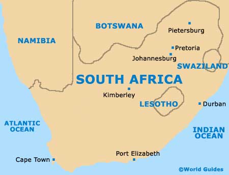
The biggest and most densely populated of all South Africa's cities, Johannesburg resides within the province of Gauteng, where it has long been the provincial capital. Currently, the city's population is around five million people, meaning that a fairly substantial transport infrastructure is now in place.
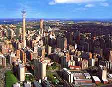
Although there is no denying that Johannesburg is a large city, it is actually fairly easy to find your way around the Jo'burg area. On the northern side of the city, two tall and rather imposing communication towers (the Hillbrow and the JG Strijdom) stand out on the skyline and always make very good points of reference, while to the north-east,
OR Tambo International Airport is connected by a busy freeway.
Maps and Orientation of the City
The very centre of Johannesburg has been based around a sensible gridwork structure and is filled with towering office blocks, particularly around Commissioner Street, where the Carlton Centre stands some 50-storeys high and dominates the area. On the western side of the city centre, Johannesburg's modern Newtown cultural precinct may well be of interest.
The northerly suburbs of Johannesburg tends to be fairly middle-class and even upper-class areas, next to the N1 and N3 highways, and contrast greatly with the black townships, which surround much of the city. For maps, head to the Map Office at Standard House, on De Korte Street.
- Bethal - (east)
- Carletonville - (west)
- Cullinan - (north-east)
- Dullstroom - (east)
- Gaborone - (north-west)
- Klerksdorp - (south-west)
- Lichtenburg - (west)
- Magaliesburg - (west)
- Orkney - (south-west)
- Parys - (south)
- Pietersburg - (north-east)
- Potchefstroom - (south-west)
- Pretoria - (north)
- Sasolburg - (south)
- Soweto - (south)
- Standerton - (south-east)
- Sun City - (north-west)
- Volkstrust - (south-east)
Continent Map of Africa

Map of South Africa
Map of Johannesburg

